
20
APR 2015We know the geography of earth today as shown in the world maps. though it is actually incorrect in depicting the actual geographical area distribution. We today know the seven continents, the five oceans, the land mass or water bodies they span across and so on.
We also know that the ancient vedic civilization was an advanced one with great achievements in science and technology, and so one becomes curious to know what was the geographical distribution mentioned in the vedic texts like? What were the names given to different parts of our planet Earth in these vedic texts?
This article is an attempt to answer such questions. But before that let us understand a bit about an ancient vedic practice – The Sankalpa – which is practiced even today.
The Sankalpa Determination
In the vedic way of life, Sankalpa means somewhat on lines of free will, a determination, a resolution, a kind of oath which one takes. The veda says that the entire universe itself was created because of a Sankalpa by the Supreme Consciousness (Narayana or Vishnu).
By making a Sankalpa the person becomes committed to the goal. Sankalpa is an expression by the Saadhaka (doer) about his goals (Saadhana). The Sankalpa becomes the foundation for a person who is all set to achieve a specific goal.
When a person makes a Sankalpa, he is also supposed to mention the time of the day when the Sankalpa was made, the geographical location where the Sankalpa was made, the purpose of the Sankalpa, the mode of achieving the goal, the name of the person doing the Sankalpa and so on. This is called Sankalpa Shlokha.
The Geographical Element of a Sankalpa
In the Sankalpa Shlokha, when one talks about the geography of the location, it starts as follows
Jambudveepe Bharatha Varshe Bharata Khande
and can go on to mention the specific location like
Mangalooru Nagare Svagrahe (meaning at my home which is in the City of Mangalore)
This is something that has been passed down for generations, being practised even today at the beginning of every vedic ritual. And in this article we talk about the the first three terms referring to geography which is Jambudvipa, Bharatha Varsha and Bharatha Khanda. People usually think that Bharatha Varsha and Bharatha Khanda mean the same, but they are not. The hierarchy in the Sankalpa Shlokha clearly says that Bharatha Khanda is inside Bharatha Varsha. So we shall see what they are. And we will also see what exactly is Jambudveepa.
Geography of the Ancient World
As per the ancient Indian Purana & Itihasa texts, in the very ancient times the entire landmass in the northern hemisphere was surrounded by ocean in all the directions. This giant land mass on earth was called Jambudvipa. Dvipa in Sanskrit means an Island. Jambudveepa consisted of modern Asia, Europe, Africa and North America.
This Jambudvipa was divided into nine varshas (geographical regions) of which one was Bharatha Varsha. The other eight varshas were Ketumula Varsha, Hari Varsha, Ilavrita Varsha, Kuru Varsha, Hiranyaka Varsha, Ramyaka Varsha, Kimpurusha Varsha, Bhadrasva Varsha.
Of these, Ilavrita Varsha was at the present North Pole (the Arctic Region)! More about this could be found in the fantastic research done by Lokamayna Bal Gangadhar Tilak in his book “The Arctic Home in the Vedas”
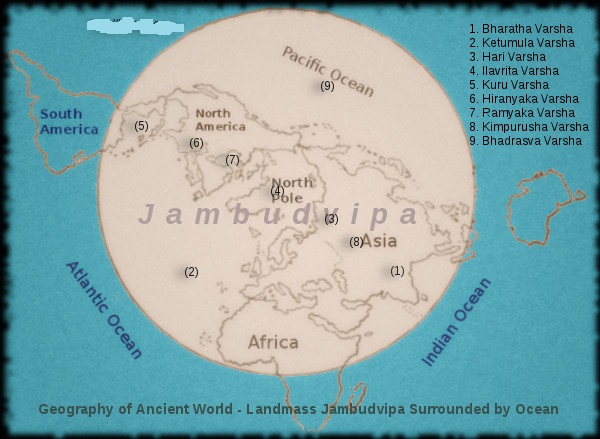
Above is the Geographical Map of the very ancient times mentioned in the Vedic texts. We have an approximate depiction of Jambudvipa and the nava varshas here. North Pole was at the exact center of Ilavrita Varsha. To the west of Ilavrita varsha was said to be Ketumula Varsha most of which is today under Atlantic Ocean. To the east of Ilvarita Varsha was Bhadrasva Varsha which is today under Pacific Ocean. On one side of the Ilavrita Varsha were Hari Varsha, Kimpurusha Varsha and Bharatha Varsha. On the other side of the Ilavrita Varsha were Ramyaka, Hiranyaka and Kuru Varsha. Kuru Varsha was hence on the opposite side of Bharatha Varsha on the globe.
It can be observed that in those times, most of South American continent, southern half of African Continent and entire Australia were submerged under water. On the other hand most of modern day Atlantic ocean and Pacific ocean, and the entire Arctic ocean were above sea level.
The Ancient Greater India – Bharathavarsha
In the Ancient Times India was called Bharathavarsha and it extended in the west including modern Egypt, Afghanistan, Baluchistan, Iran, Sumeria upto Caspian Sea (which was called Kashyapa Samudra in those days). Bhratahvarsha was the Greater India while Bharatha Khanda referred to the Indian Subcontinent which lies at the heart of the Vedic Civilization and extended from Himalayas in the north to KanyaKumari in the South. So the aryan invasion theory of a migration of Aryans from Central Asia to modern northern India is a baseless theory, for the entire ancient aryan civilizational geography spanned across the above mentioned regions. The very term “arya” in Sanskrit refers not to any race, but actually means a “noble person”.
The Puranas and Ithihasas are full of historical developments in the Bharatha Varsha. The now dried up Saraswati river mentioned numerous times in the vedas is the heart of this vedic civilization, and it is from here the vedic civilization spread across the Bharatha Varsha during the vedic period. The “Out of India” theory talks about this. The Saraswati river dried up at the end of the Mahabharatha Period due to geological events in the region. It was around this time that the earlier lush green area of the present Rajasthan had got converted into a desert as we see it today.
During the ancient times Arabian sea did not exist, and the land mass stretched continuously from modern India to Africa. The mighty Saraswati river born in the Himalayas flowed for over 4500 miles into Africa before entering the Oceans. This was the largest and longest river in those days. This is the most mentioned and praised river in the Veda. Of the three Ganga Yamuna Saraswati – we know the existence of the first two rivers which flow even today, and Saraswati till recent times was thought to be a mythical river. But recent satellite photographs and geological data have proved the existence of an ancient mighty Saraswati river and its geographical span.